Saturday, February 6, 2010

11. Seaside Village and New Urbanism


Seaside is a planned resort community on the Florida panhandle roughly midway between Fort Walton Beach and Panama City, It was designed by planners Andres Duany and Elizabeth Plater-Zybeck.


The community is often cited as the first New Urbanist development. At the time of Seaside's construction,
Walton County had no zoning ordinance, leaving Seaside's founders able to plan with a comparatively free
hand. In the absence of these regulations (e.g., minimum lot size, separation of uses), the planners were able to design a mixed-use development with densities greater than conventional sub-urban development.


Image: Seasides's very fine beach and white sand.


New Urbanism is a sincere effort on the part of its proponents to return society to more pedes-
trian-friendly lifestyle. Cars however, still dominate and penetrate even to the core of their developments where the pedestrian alone should have free reign!


Image Above: A pedestrian lane.
New Urbanism is a sincere effort on the part of its proponents to return society to more pedestrian-friendly lifestyle. Cars however, still dominate and penetrate even to the core of their developments where the pedestrian alone should have free reign!

Notice in the town plan below that each residential lot is fronted by a street that provides car access and backed by a narrow pedestrian lane that leads to the commercial center and beach.


Seaside has had a significant impact on urban planning in many cities. New Urbanist developments continue to proliferate across North America, and many planners and urban designers are beginning to understand the importance of mixed-use and higher density communities. New Urbanists want to restore the sense of community that was lost in American suburbs. They understand the need to stop cars from dominating the urban scene.


New Urbanism by and large re-visits early 20th century urban forms such as the streetcar suburbs that were built in the USA in the early 1920's. The motorcar was already a presence but had not yet dominated the urban scene as it does today, It tends to adopt the suburban grid as the basis for city design and always use small blocks and a close-knit web of lanes and streets.


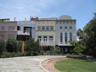
Images: The Post Office above and mixed-use building below.


New Urbanism proposes the13 points of pedestrian-oriented development:
1. The neighborhood has a discernible center. This is often a square or a green and sometimes a busy or memorable street corner. A transit stop would be located at this center.
2. Most of the dwellings are within a five-minute walk of the center, an average of roughly 2,000 feet.
3. There are a variety of dwelling types, usually houses, rowhouses and apartments, so that younger and older people, singles and families, the poor and the wealthy may find places to live.
4. At the edge of the neighborhood, there are shops and workplaces (and/or transit stations leading to workplaces) of sufficiently varied types to supply the weekly needs of a household. (Collective neighborhood edges form a town center.)
5. An elementary school is close enough so that most children can walk from their home.
6. There are small playgrounds accessible to every dwelling - not more than a tenth of a mile away.
7. Streets within the neighborhood form a "connected network, which disperses traffic by providing a variety of pedestrian and vehicular routes to any destination.
8. The streets are relatively narrow and shaded by rows of trees. This slows traffic, creating an environment suitable for pedestrians and bicycles.
9. Buildings in the neighborhood center are placed close to the street, creating a well-defined outdoor room.
10. Parking lots and garage doors rarely front the street. Parking is relegated to the rear of buildings, usually accessed by alleys.
11. Certain prominent sites at the termination of street vistas or in the neighborhood center are reserved for civic buildings.
These provide sites for community meetings, education, and religious or cultural activities.
12. The neighborhood is organized to be self-governing. A formal association debates and decides matters of maintenance, security, and physical change. Taxation is the responsibility of the larger community.
13. For single-family homes: A small ancillary building is permitted within the backyard of each house. It may be used as a rental unit or place to work (e.g., office or craft workshop).


.Images: The Chapel above and the Urban Center below.


Allied with the New Urbanist movement are contemporary forms of architecture such as the "New Classicism" or "Traditional Architecture." Their exponents understand the worth of historical urban forms, including the curved street. Possibly the best single book is Léon Krier's Architecture: Choice or Fate. See also Lucien Steil’s "Tradition and Modernity in Contemporary Practice."
Tuesday, February 2, 2010

10. The Squares of Savannah - "The Most Intelligent Grid"

The city of Savannah, Georgia, United States, was laid out in 1733 around four open squares. The plan anticipated growth of the city and thus expansion of the grid; additional squares were added during the eighteenth and nineteenth centuries, and by 1851 there were twenty-four squares in the city.


Savannah's city plan has been called "the most intelligent grid in America, perhaps the world", and Edmund Bacon wrote that "it remains as one of the finest diagrams for city organization and growth in existence."


 The American Society of Civil Engineers has honored the plan for Savannah as a National Historic Civil Engineering Landmark, and in 1994 the plan was nominated for inclusion in the UNESCO World Heritage List.


Most of Savannah's squares are named in honor or in memory of a person, persons or historical event, and many contain monuments, markers, memorials, statues, plaques, and other tributes.


Savannah was founded by General James Oglethorpe. Although cherished by many today for their aesthetic beauty, the first squares were originally intended to provide colonists space for military exercises. A square was established for each ward of the new city. The first four themselves formed a larger square on the bluff overlooking the Savannah River. The original plan actually called for six squares, and as the city grew the grid of wards and squares was extended so that twenty-four squares were eventually created on a six-by-five grid. 


Image above: Layout of a typical ward in Oglethorpe's plan.

All of the squares measure approximately 200 feet from north to south, but they vary east to west from approximately 100 to 300 feet. Typically, each square is intersected north-south and east-west by wide, two-way streets. Traffic flows counterclockwise around the squares, which thus function much like traffic circles.


Each square sits at the center of a ward. The lots to the east and west of the squares, flanking the major east-west axis, were considered "trust lots" in the original city plan and intended for large public buildings such as churches, schools, or markets.


The remainder of the ward was divided into four areas, called tythings, each of which was further divided into ten residential lots. This arrangement is illustrated in the 1770 Plan of Savannah. The distinction between trust lot and residential lot has always been fluid. Some grand homes, such as the well-known Mercer House, stand on trust lots, while many of the residential lots have long hosted commercial properties.


All of the squares are a part of Savannah's historic district and fall within an area of less than one half square mile. The five squares along Bull Street—Monterey, Madison, Chippewa, Wright, and Johnson—were intended to be grand monument spaces and have been called Savannah's "Crown Jewels." Many of the other squares were designed more simply as commons or parks, although most serve as memorials as well.
The squares are a major point of interest for millions of tourists visiting Savannah each year, and they have been credited with stabilizing once-deteriorating neighborhoods and revitalizing Savannah's downtown commercial district.


Lessons from Savannah;
1. Use Savannah's "intelligent grid" to relieve the monotony of the common gridiron street pattern.
2. Landscaped Squares bring nature right into the heart of the development.

Monday, February 1, 2010

9. Montpazier - Beauty and the Beast

Monpazier, founded in 1284, is regarded as the model of all "bastide" or planned garrison villages because of its perfect layout, and the quality of its buildings. Perched on the summit of a gentle hill, Monpazier is an ideal base to explore the rich variety of attractions of the Périgord region of France. A rectilinear street pattern is a thing of beauty, but only in small doses. Extend the pattern too far and the beauty turns into a beast!


The beautiful Bastide village of Montpazier in France.


Monpazier's Rectilinear Plan. Note the Central Market Square.


New European towns were planned using grids beginning in the 12th century, most prodigiously in the bastides of southern France that were built during the 13th and 14th centuries. Medieval European new towns using grid plans were widespread, ranging from Wales to the Florentine region. Many were built on ancient grids originally established as Roman colonial outposts.

Gridiron patterns were invented by logical minds intent on control. Miletus was the first planned Greek city, built to a grid plan after 479 BC. Its gridiron design has been credited to Hippodamus a Greek intellectual associated with the Pythagoreans.


The town of Priene, set on uneven ground is a good example of Ionian grid planning.

The grid plan was a common tool of Roman city planning, based originally on its use in military camps known as castra. The Roman grid is characterized by a nearly perfectly orthogonal layout of streets, all crossing each other at right angles, and by the presence of two main streets, set at right angles from each other.


Bastides are towns planned and built as a single unit, by a single founder. The majority of bastides have a grid layout of intersecting streets, with wide thoroughfares that divide the town plan into blocks, through which a narrow lane often runs.


There is a central market square surrounded by arcades through which the axes of thoroughfares pass, with a covered measuring area.


The Market Building above and below.


The market square often provides the module into which the bastide is subdivided. The Roman model, the castrum with its grid plan and central forum, was inescapable in a region where Roman planning precedents remained in medieval cities like Béziers, Narbonne, Toulouse, Orange and Arles.


The Bastide towns in France prove that gridiron streets can be beautiful if limited in area. If the gridiron pattern is repeated too extensively, the beauty turns into a beast of monotony!


Image above: Street scene with cars. The area near center of Monpazier is varied and interesting whereas further out is dull and boring just as so many other gridiron street patterrned villages everywhere.


The Lessons from Monpazier:
1. A rectilinear street pattern is great if limited in extent.
2. Provide a marketplace in the piazza or village square for the sale of fresh produce.
3. Surround your piazza with arcaded walkways.

Images: 1)Marco E Fiorenza 2)PhillipC 3)farm2.static 4)Ling_priene 5)PittsburgSteve 6)tourisme-aquitane 7)kedeld 8-11)PhillipC 12)aeefe